
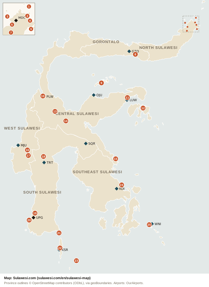
Map of Sulawesi
Sulawesi lies in central Indonesia, east of Borneo. Four long peninsulas meet in its mountainous centre. The island has six provinces. The map shows them, the 25 destinations of this site, numbered, and the airports travellers use.
Destinations on the map
North Sulawesi
Gorontalo
Central Sulawesi
West Sulawesi
South Sulawesi
Southeast Sulawesi
The six provinces
Central Sulawesi is the largest province, and South Sulawesi has the most people. Gorontalo split from North Sulawesi in 2000, and West Sulawesi from South Sulawesi in 2004.
| Province | Capital | Destinations |
|---|---|---|
| North Sulawesi | Manado | 7 |
| Gorontalo | Gorontalo | 1 |
| Central Sulawesi | Palu | 7 |
| West Sulawesi | Mamuju | 2 |
| South Sulawesi | Makassar | 6 |
| Southeast Sulawesi | Kendari | 2 |
Airports
Flights from outside Indonesia land in Makassar (UPG) and Manado (MDC). The other airports have domestic flights. Routes and airlines are in How to get to Sulawesi and Getting around Sulawesi.
| Airport | Code | Town |
|---|---|---|
| Sam Ratulangi International Airport | MDC | Manado |
| Djalaluddin Airport | GTO | Gorontalo |
| Mutiara SIS Al-Jufrie Airport | PLW | Palu |
| Tanjung Api Airport | OJU | Ampana |
| Syukuran Aminuddin Amir Airport | LUW | Luwuk |
| Tampa Padang Airport | MJU | Mamuju |
| Sorowako Airport | SQR | Sorowako |
| Toraja Airport | TRT | Tana Toraja |
| Sultan Hasanuddin International Airport | UPG | Makassar |
| H. Aroeppala Airport | KSR | Selayar |
| Haluoleo Airport | KDI | Kendari |
| Matahora Airport | WNI | Wangi-Wangi, Wakatobi |
Use this map
You may use this map on a website, in a guide or in print, free of charge. Keep the credit under the map, and link to this page.
Code to show it on your site
<a href="https://sulawesi.com/en/sulawesi-map"><img src="https://sulawesi.com/en/sulawesi-map.svg" alt="Map of Sulawesi with its six provinces, destinations and airports" width="720" height="986"></a>The credit under the map must stay: the province outlines are OpenStreetMap data (ODbL).
More about Sulawesi
The key figures of the island, with their sources, are in Sulawesi at a glance. Distances and drive times between the main places are on the road routes page, and the weather of each place now and by month is on the weather page.
Province outlines: OpenStreetMap contributors, via geoBoundaries (ODbL 1.0). Airport positions: OurAirports (public domain). Destination positions: the villages BMKG forecasts for, OpenStreetMap and Wikipedia.